
Debbie's Guidebook
THINGS TO VISIT AND EXPERIENCE
Here are a few nearby destinations that I love and hope you will too! Enjoy your travels!
( Travel Time= 10-15 minutes ) Camping, fishing, boating (including water-skiing and jet skiing), swimming, hiking, climbing, hunting, picnicking, photography, and the mountain and desert scenery share most visitors' to-do lists. Winter months bring migratory birds; eagles and osprey are most visitors' favorites.
27 現地メンバーのおすすめ
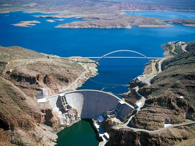
Theodore Roosevelt Dam
( Travel Time= 10-15 minutes ) Camping, fishing, boating (including water-skiing and jet skiing), swimming, hiking, climbing, hunting, picnicking, photography, and the mountain and desert scenery share most visitors' to-do lists. Winter months bring migratory birds; eagles and osprey are most visitors' favorites.
( Travel Time= 25 minutes. ) Well-preserved cliff dwellings were occupied by the Salado culture during the 13th- 15th centuries. Some of the artifacts excavated nearby are on display in the visitor center museum which is free to visit. Tonto National Monument showcases two Salado-style cliff dwellings. Colorful pottery, woven cotton cloth, and other artifacts tell a story of people living and using resources from the northern Sonoran Desert from 1250 to 1450 CE.
The Lower Cliff Dwelling is open year-round. It is a steep 0.5 mile walk uphill on a paved path. When you arrive, check in at the Visitor Center, and start your hike before 4:00 p.m. During the months of June, July and August, start your hike before 12:00 p.m (noon). Hiking to the Lower Cliff Dwelling is about one hour round-trip. Cost- 10$
Visiting the Upper Cliff Dwelling is accessible by guided tour only. The tour takes 3 to 4 hours. Tours are offered every Friday, Saturday, Sunday, and Monday from January through April. To make a reservation, you must call (928)467-2241.
The Visitor Center offers a great introduction to the people and way of life that occupied this place 700 years ago. Explore the newly remodeled museum and replica room, watch the 18 minute park film, and browse throughout the bookstore, operated by Western National Parks Association.
16 現地メンバーのおすすめ
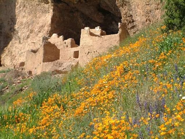
トント国立記念物
26260 AZ-188( Travel Time= 25 minutes. ) Well-preserved cliff dwellings were occupied by the Salado culture during the 13th- 15th centuries. Some of the artifacts excavated nearby are on display in the visitor center museum which is free to visit. Tonto National Monument showcases two Salado-style cliff dwellings. Colorful pottery, woven cotton cloth, and other artifacts tell a story of people living and using resources from the northern Sonoran Desert from 1250 to 1450 CE.
The Lower Cliff Dwelling is open year-round. It is a steep 0.5 mile walk uphill on a paved path. When you arrive, check in at the Visitor Center, and start your hike before 4:00 p.m. During the months of June, July and August, start your hike before 12:00 p.m (noon). Hiking to the Lower Cliff Dwelling is about one hour round-trip. Cost- 10$
Visiting the Upper Cliff Dwelling is accessible by guided tour only. The tour takes 3 to 4 hours. Tours are offered every Friday, Saturday, Sunday, and Monday from January through April. To make a reservation, you must call (928)467-2241.
The Visitor Center offers a great introduction to the people and way of life that occupied this place 700 years ago. Explore the newly remodeled museum and replica room, watch the 18 minute park film, and browse throughout the bookstore, operated by Western National Parks Association.
( Travel Time= 30 minutes. ) The Apache Trail in Arizona was a stagecoach trail that ran through the Superstition Mountains. It was named the Apache Trail after the Apache Indians who originally used this trail to move through the Superstition Mountains.
The awe-inspiring and historic Apache Trail, also known as Highway 88, takes visitors from Roosevelt Lake and Tonto National Monument to Apache Junction, AZ through the Superstition Mountains and Tonto National Forest along a 39-mile mostly unpaved road. This gravel stretch is maintained for passenger vehicles, but the drive is slow. It is not recommended for large RVs or caravans. Visit the Apache Trail Scenic Byway webpage for additional information.
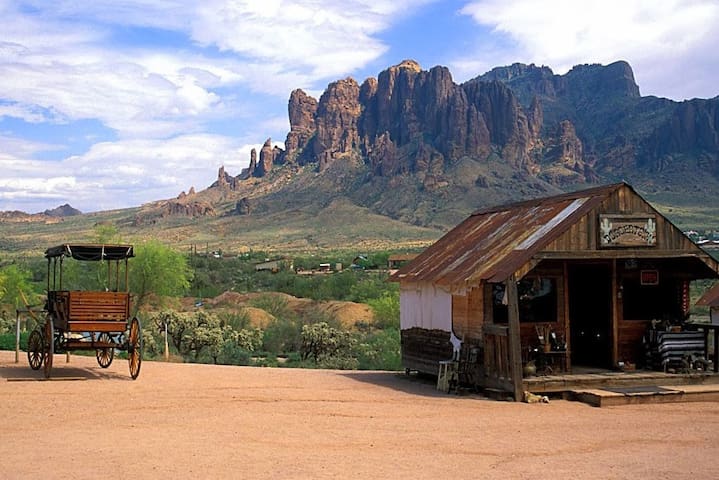
Apache Trail
Apache Trail( Travel Time= 30 minutes. ) The Apache Trail in Arizona was a stagecoach trail that ran through the Superstition Mountains. It was named the Apache Trail after the Apache Indians who originally used this trail to move through the Superstition Mountains.
The awe-inspiring and historic Apache Trail, also known as Highway 88, takes visitors from Roosevelt Lake and Tonto National Monument to Apache Junction, AZ through the Superstition Mountains and Tonto National Forest along a 39-mile mostly unpaved road. This gravel stretch is maintained for passenger vehicles, but the drive is slow. It is not recommended for large RVs or caravans. Visit the Apache Trail Scenic Byway webpage for additional information.
( Travel Time= 1hr 15 minutes ) Besh-Ba-Gowah is a 200-room prehistoric Salado masonry pueblo located atop a broad ridge overlooking Pinal Creek. The site is situated one mile southwest from Globe, Arizona and surrounded by a small city park and adjacent museum with excavated items including prehistoric pottery, stone and woven artifacts.
Open Daily 9-4:30
Closed- Thanksgiving, Christmas, and New Year’s Day
Summer Hours
July 1 - September 30- Closed Monday & Tuesday
Admission Cost
Adults $5
Seniors (65+) $4
Children (12- ) FREE
Contact Information
1324 S. Jesse Hayes Rd. Globe, AZ 85501
(928) 425-0320
beshbagowah@globeaz.gov
12 現地メンバーのおすすめ
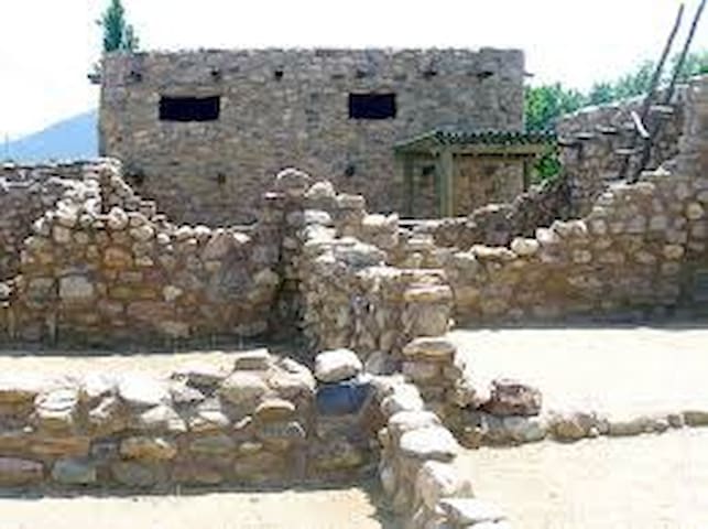
Besh-Ba-Gowah Museum
1324 S Jesse Hayes Rd( Travel Time= 1hr 15 minutes ) Besh-Ba-Gowah is a 200-room prehistoric Salado masonry pueblo located atop a broad ridge overlooking Pinal Creek. The site is situated one mile southwest from Globe, Arizona and surrounded by a small city park and adjacent museum with excavated items including prehistoric pottery, stone and woven artifacts.
Open Daily 9-4:30
Closed- Thanksgiving, Christmas, and New Year’s Day
Summer Hours
July 1 - September 30- Closed Monday & Tuesday
Admission Cost
Adults $5
Seniors (65+) $4
Children (12- ) FREE
Contact Information
1324 S. Jesse Hayes Rd. Globe, AZ 85501
(928) 425-0320
beshbagowah@globeaz.gov
Sightseeing
Dominating the skyline east of Tonto Basin is 6451 foot Picture Mountain, so named for the rock slides on its face that resemble a horseback rider with weapon raised, riding towards some sort of animal. Picture Mountain forms the southern corner of a forested plateau in the northern Sierra Anchas where Pleasant Valley War participant Jake Lauffer, and later legendary cattleman George Cline once ran cattle. Traveling the precipitous, rocky road up to where the trail starts is an adventure in itself! Usually the road is high clearance, bordering on 4x4.
Beginning at a large pull off area on the south side of forest road 609, start following an old unmarked jeep trail as it heads southeast into the forest. This is actually forest road 875, which is not really a road at all anymore. (seriously, don't try to drive this-you'll see why later!) At the 0.15 mile point, the old road forks. Turn right here, onto the west fork (gps coordinates: 33.94382 N 111.16332 W). The old road/trail turns south here, and continues its gentle climb up through the scrub oak and ponderosas. The trail soon begins a steep climb straight up the northern slope of Picture Mountain. As you ascend higher, the Sierra Anchas, Mazatzals, and the Mogollon Rim rise up behind you over the tree tops.
Soon you will reach the top of the ridge that forms the spine of Picture Mountain, and enter a low and open forest of pinyon, oak and juniper. This stretch is relatively level, and views to the north and east abound. In the distance is Pleasant Valley where Young is located, beneath the Naegelin Rim. After 1.1 miles, the jeep trail comes to a little rocky clearing, and starts to descend to the left. Leave the old jeep trail behind here (gps coordinates: 33.93180 N 111.16315 W), and keep heading uphill on the ridge. The ridge begins to narrow as it nears the top of the mountain, and magnificent views to the west open up over Picture Mountain's craggy western face. Fourteen hundred feet below is the twisting brown 609 road, with Tonto Basin and the rugged Mazatzals forming the backdrop. Just before the ridge starts to descend, you will come to the apex of Picture Mountain. If you look carefully, you will discover the metal survey and triangulation station caps set into the mountain top's orange Precambrian quartzite. If you continue south down the southern slope of the mountain for a few hundred feet, you will arrive at a rocky shelf: a perfect place to sit, rest, and take in the limitless panorama to the south. Return the way you came.
Back at the trailhead, a 0.75 mile round trip hike to the west down the 609 road will bring you to the ruins of a Salado or Anchan dwelling next to the south side of the road. The walls have collapsed into piles of rocks in this approximately 100 foot by 300 foot ruin, but it is still worth checking out before heading home. Enjoy
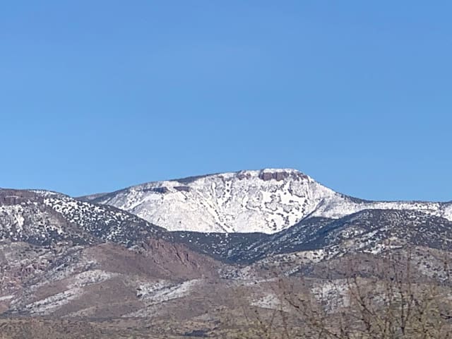
Picture Mountain
Dominating the skyline east of Tonto Basin is 6451 foot Picture Mountain, so named for the rock slides on its face that resemble a horseback rider with weapon raised, riding towards some sort of animal. Picture Mountain forms the southern corner of a forested plateau in the northern Sierra Anchas where Pleasant Valley War participant Jake Lauffer, and later legendary cattleman George Cline once ran cattle. Traveling the precipitous, rocky road up to where the trail starts is an adventure in itself! Usually the road is high clearance, bordering on 4x4.
Beginning at a large pull off area on the south side of forest road 609, start following an old unmarked jeep trail as it heads southeast into the forest. This is actually forest road 875, which is not really a road at all anymore. (seriously, don't try to drive this-you'll see why later!) At the 0.15 mile point, the old road forks. Turn right here, onto the west fork (gps coordinates: 33.94382 N 111.16332 W). The old road/trail turns south here, and continues its gentle climb up through the scrub oak and ponderosas. The trail soon begins a steep climb straight up the northern slope of Picture Mountain. As you ascend higher, the Sierra Anchas, Mazatzals, and the Mogollon Rim rise up behind you over the tree tops.
Soon you will reach the top of the ridge that forms the spine of Picture Mountain, and enter a low and open forest of pinyon, oak and juniper. This stretch is relatively level, and views to the north and east abound. In the distance is Pleasant Valley where Young is located, beneath the Naegelin Rim. After 1.1 miles, the jeep trail comes to a little rocky clearing, and starts to descend to the left. Leave the old jeep trail behind here (gps coordinates: 33.93180 N 111.16315 W), and keep heading uphill on the ridge. The ridge begins to narrow as it nears the top of the mountain, and magnificent views to the west open up over Picture Mountain's craggy western face. Fourteen hundred feet below is the twisting brown 609 road, with Tonto Basin and the rugged Mazatzals forming the backdrop. Just before the ridge starts to descend, you will come to the apex of Picture Mountain. If you look carefully, you will discover the metal survey and triangulation station caps set into the mountain top's orange Precambrian quartzite. If you continue south down the southern slope of the mountain for a few hundred feet, you will arrive at a rocky shelf: a perfect place to sit, rest, and take in the limitless panorama to the south. Return the way you came.
Back at the trailhead, a 0.75 mile round trip hike to the west down the 609 road will bring you to the ruins of a Salado or Anchan dwelling next to the south side of the road. The walls have collapsed into piles of rocks in this approximately 100 foot by 300 foot ruin, but it is still worth checking out before heading home. Enjoy